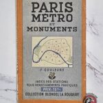
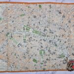


Original folding tourist map of Paris titled Paris Métro et Monuments, published by the well-known French cartographic firm Blondel La Rougery. This colorful pocket guide features a detailed street map of central Paris highlighting major monuments, landmarks, parks, and points of interest, along with a complete Paris Metro system map and station index.
The map is marked with a 1945 legal deposit date, placing it in the immediate post-war period following the liberation of Paris. It provides a fascinating snapshot of the city’s transportation network and urban layout as it appeared at the end of the Second World War.
Printed in full color and designed for tourists and visitors, the guide includes an alphabetical index of Metro stations, a list of major monuments, museums, churches, public buildings, and other notable attractions throughout Paris.
An attractive historical souvenir and a desirable piece for collectors of vintage travel memorabilia, transportation history, cartography, and post-war French ephemera.
Condition: Original period example showing normal age-related wear from handling and folding. Remains complete and displays well.
Size 36 x 24 cm approx